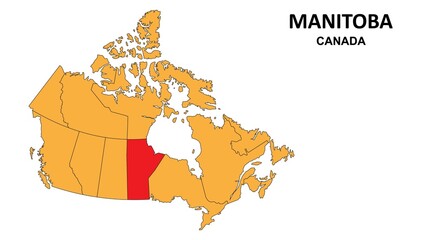
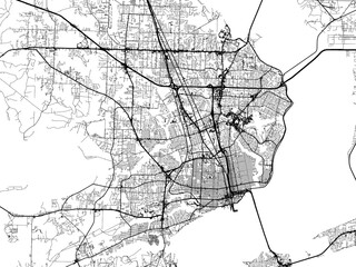
WallsHeaven makes decorative wall murals in high quality printing

74,956 Design+region+america Wall Murals - Canvas Prints - Stickers

Asian Pacific American Heritage Month. Celebrated in May. It celebrates the culture, traditions and history of Asian Americans and Pacific Islanders in the United States. Poster, card, banner. Vector
north carolina state home sign - PNG image with transparent background
Massac County, Illinois (U.S. county, United States of America, USA, U.S., US) map vector illustration, scribble sketch Massac map
African ethnic tribal fabric patterns, featuring symbols of African ethnic from the past. These ethnic and classic designs are beautifully colored, creating exceptional textiles for the peach industry
Newfoundland and Labrador Map Black | Province Border | Canada State | Canadian | America | Transparent Isolated | Variations
Black location map of the Panamanian Kuna de Wargandí region inside gray map of Panama
Thanksgiving day greeting card. Decorative frame with fall leaves, sunflowers, berries, fruits and vegetables and text Happy Thanksgiving Day.
gangwon do map. detailed south korea city, provinces vector map series.
Map of the Westside region in Los Angeles County
goat on forest snow vector illustration flat design
Hispanic heritage month. Abstract ornament background design, retro style with text, celebration
Harvest, thanksgiving day watercolor illustrations Pumpkins and sunflower flowers autumn compositions in vintage style.
Delaware state map outline logo design
World Map Americas Centered Map. Old colors
Cactus vector illustrations. Hand drawn cactus plants set
Seamless pattern with tropical leaves.
Manitoba Map is highlighted on the Canada map with detailed state and region outlines.
Map of the city of Allentown Pennsylvania with an American Flag overlay.
Side portrait of a beautiful African or African-American woman with curly hair and closed eyes. Flat vector illustration. Beautiful simple AI generated image in 4K, unique.
American Red Blue White groovy hippie flowers, mushrooms, rainbow vector seamless pattern. Patriotic USA Independence Day floral background. 4th of July surface design for packaging, scrap book
May is Asian Pacific American Heritage Month (APAHM), Selective focus with excessive noise,compression artifacts and film grain filter. Generative AI
State Tennessee map on transparent background. Tennessee map with  regions in gray for your web site design, logo, app, UI. USA. EPS10.
State Tennessee map on transparent background. Tennessee map with regions in gray for your web site design, logo, app, UI. USA. EPS10.
Pittsburg County, Oklahoma State (U.S. county, United States of America, USA, U.S., US) map vector illustration, scribble sketch Pittsburg map
Indian ethnic tribal fabric patterns featuring red geometric designs accentuated with yellowtones. These patterns ethnic beauty of intricate and ethnic vibrant images, meticulously crafted for
State of Kansas. Map of Kansas. United States of America Kansas. State maps. Vector illustration
Oklahoma state USA watercolor map in front of a white background
Central American Flags Mosaic Artwork Display
ecuador map. detailed south america country map vector.
shadow map of Hawaii state
A detailed map of Reading, Pennsylvania, rendered in a minimalist style. The map features a dark blue background with white lines representing streets and roads.
Abstract - High Detailed Gold Map of Central America. Vector illustration eps10.
Hispanic Heritage Frame Vector Design
World map on white background. All countries in The World Abstract Color Gradient. Can use for printing, website, presentation element, textile. World map vector illustration, high-resolution, travel.
world map. Highly detailed map of the detailed borders of all countries in blue colors.
City map Havana, detailed urban planning travel vector poster design
Scribble-style Google Maps screenshot of Austin, Texas. Features green/red pins, yellow popups, bright leaf, light blue roads, and black traffic arrows.
Hand drawn sketch style hummingbird and orchid flowers isolated on white background. Vector illustration.
Illustration of a map of the city of  Overland Park Kansas in the United States of America with white roads on a icy blue frozen background.
Illustration of a map of the city of Overland Park Kansas in the United States of America with white roads on a icy blue frozen background.
Building view with landmark of Bellevue is a city in the Eastside region of United States. Watercolor splash with hand drawn sketch illustration in vector.
Guayaquil - ECUADOR city flag. Light blue and white. White stars. Flat and waving Guayaquil Flag. Vector illustration. Flag wavy abstract background.
USA concept represented by map and flag icon. isolated and flat illustration
Blank map Brazil. High quality map Brazil with provinces on transparent background for your web site design, logo, app, UI. Stock vector. Vector illustration EPS10.
Osage County, Oklahoma State (U.S. county, United States of America, USA, U.S., US) map vector illustration, scribble sketch Osage map
African tribal cloth pattern featuring red tones and a modern geometric style. These designs stand out with their playful use of colors a soft and visually appealing image. Crafted meticulously
Pattern of watercolor cactus, succulent, illustration on white background. Natural watercolor design elements, botanical collection. Design for textile, fabric, print, wrapping, paper.Seamless pattern
North Carolina outline state of USA. Map in black and white color options. Vector Illustration..
Vintage hand drawn illustrations with cactus and succulents in engraving style. Sketches of floral objects isolated on white for design
chungcheong buk do map. detailed south korea city, provinces vector map series.
3d Map of New Mexico state with counties, color. United State of America, US, United State
colombia flag pattern ceramic tile. geometric background. vector illustration
Map of the San Fernando Valley region in Los Angeles County
Map of chaves County in New Mexico state on white background. single County map highlighted by black color on New Mexico map. UNITED STATES, US
Map of Santa Fe County in New Mexico state on white background. single County map highlighted by black color on New Mexico map. UNITED STATES, US
3d Map of Nevada state with counties and color. United State of America, US, United State
Portsmouth independent city location highlighted by black color on Virginia state map, United States, usa, us
Lexington independent city location highlighted by black color on Virginia state map, United States, usa, us
Vector road map of the city of  Pensacola  Florida in the United States of America with black roads on a white background.
Vector road map of the city of Pensacola Florida in the United States of America with black roads on a white background.
Vector road map of the city of  Omaha Nebraska in the United States of America with white roads on a black background.
Vector road map of the city of Omaha Nebraska in the United States of America with white roads on a black background.
Cherokee County, Oklahoma State (U.S. county, United States of America, USA, U.S., US) map vector illustration, scribble sketch Cherokee map
St. Clair County, Illinois (U.S. county, United States of America, USA, U.S., US) map vector illustration, scribble sketch Saint Clair map
Staunton independent city location highlighted by black color on Virginia state map, United States, usa, us
Uberlandia City (Federative Republic of Brazil, Minas Gerais State) map vector illustration, scribble sketch City of Uberlandia map
African ethnic pattern is inspired by the traditional clothing of African ethnic , featuring distinctive red and white tones. The design captures the essence of ethnic aesthetics, making it an ideal
Department of Piura (Republic of Peru, Regions of Peru) map is designed cannabis leaf green and black, Piura map made of marijuana (marihuana,THC) foliage....
1:1 square aspect ratio vector road map of the city of  Lee's Summit Missouri in the United States of America with white roads on a black background.
1:1 square aspect ratio vector road map of the city of Lee's Summit Missouri in the United States of America with white roads on a black background.
Beaufort County, State of South Carolina (U.S. county, United States of America, USA, U.S., US) map vector illustration, scribble sketch Beaufort map
Arlington independent city location highlighted by black color on Virginia state map, United States, usa, us
alexandria independent city location highlighted by black color on Virginia state map, United States, usa, us
Vector road map of the city of  Monroe Louisiana in the United States of America on a white background.
Vector road map of the city of Monroe Louisiana in the United States of America on a white background.
Okmulgee County, Oklahoma State (U.S. county, United States of America, USA, U.S., US) map vector illustration, scribble sketch Okmulgee map
Noble County, Oklahoma State (U.S. county, United States of America, USA, U.S., US) map vector illustration, scribble sketch Noble map
Ramsey County, North Dakota State (U.S. county, United States of America, USA, U.S., US) map vector illustration, scribble sketch Ramsey map
Monroe County, Illinois (U.S. county, United States of America, USA, U.S., US) map vector illustration, scribble sketch Monroe map
Macon County, Illinois (U.S. county, United States of America, USA, U.S., US) map vector illustration, scribble sketch Macon map
Lawrence County, Illinois (U.S. county, United States of America, USA, U.S., US) map vector illustration, scribble sketch Lawrence map
Jersey County, Illinois (U.S. county, United States of America, USA, U.S., US) map vector illustration, scribble sketch Jersey map
Watauga County, North Carolina State (U.S. county, United States of America, USA, U.S., US) map vector illustration, scribble sketch Watauga map
Warren County, North Carolina State (U.S. county, United States of America, USA, U.S., US) map vector illustration, scribble sketch Warren map
African ethnic fabric pattern showcases a stunning contrast of black and white tones, enhanced with watercolor techniques that add a unique vibrancy and depth to the design. The use of watercolor
Map of Thayer County in Nebraska state on white background. single County map highlighted by black colour on Nebraska map. UNITED STATES, US
3d Map of Nevada state with counties and color. United State of America, US, United State


Why Wallsheaven is special?

30 Days on Returns

You can return or replace any product within 30 days without reason.

Free Express Delivery

Delivery is free for all of our products, wherever you are.

Eco Water-Based Inks

Our prints are odorless, ecological, and safe for children with vivid colors from natural dyes.

Simple Installation

Installing WallsHeaven's wallpaper mural is as easy as making paper airplane.

Artist Support

By choosing our photos, you will support the artists from all over the world.